RMI contribution to Satellite Application Facility on Support to Operational Hydrology and Water Management (H-SAF)

Context and objectives
The "EUMETSAT Satellite Application Facility on Support to Operational Hydrology and Water Management (H-SAF, http://hsaf.meteoam.it/)" was established on July 2005, as part of the EUMETSAT SAF Network. The RMI is actively involved in the use and evaluation of these products.
The main H-SAF objective is to provide new satellite-derived products from existing and future satellites with sufficient time and space resolution to satisfy the needs of operational hydrology. H-SAF provides a variety of products for precipitation, soil moisture and snow parameters.
The products are obtained by processing of data from Earth observation satellites, in geostationary and polar orbits, operated by EUMETSAT and other organizations. During the process, data from microwave and infrared instruments are used (MW conical and cross-track scanners, GEO/IR, radar scatterometers, VIS/IR and MW radiometry). The aim is to reach the best possible accuracy compatible with satellite systems available today or in the near future.
The mission of the H-SAF project is to process hydrometeorological satellite data and organise the results in product families, according to the physical variable or parameter considered (precipitation rain rate or accumulation, soil moisture and several snow parameters). The validation activities constitute an essential part of the whole process.
Currently, the following products are available:
- Precipitation
- PR-OBS-1 (H01, Precipitation Rain Rate at ground by MW conical scanners)
- PR-OBS-2 (H02, Precipitation Rain Rate at ground by MW cross-track scanners)
- PR-OBS-3 (H03, Precipitation Rain Rate at ground by GEO/IR supported by LEO/MW)
- PR-OBS-5 (H05, Accumulated Precipitation at ground by blended MW and IR)
- PR-OBS-6A (H15, Blended SEVIRI Convection Area/ LEO MW Convective Precipitation)
- Soil moisture
- SM-OBS-2 (H08, Small Scale Surface Soil Moisture by Radar Scatterometer)
- SM-DAS-2 (H14, Profile Index in the roots region by Scatterometer Data Assimilation)
- H101-H102-H16-H103 (Surface Soil Moisture MetOp ASCAT A/B NRT Orbit)
- Snow
- SN-OBS-1 (H10, Snow detection by VIS/IR radiometry)
- SN-OBS-2 (H11, Snow status - dry/wet - by MW radiometry)
- SN-OBS-3 (H12, Effective snow cover by VIS/IR radiometry)
- SN-OBS-4 (H13, Snow water equivalent by MW radiometry)
Other products are also under development.
The dissemination of the products is carried out through the following channels:
EUMETCast for all NRT SAF products
EUMETSAT Data Centre for all Off-line SAF products
The H-SAF product spatial coverage is delimited by the following coordinates range: 25°N to 75°N latitude, 25°W to 45°E longitude. As of now, the precipitation products have also a full disk version. Moreover, the soil moisture product SM-DAS-2 provides global coverage.
The H-SAF products are regularly validated using ground-based measurements (radar and rain-gauge data for precipitation, model and in-situ data for soil moisture, snow parameters from stations for snow products). This ensures the necessary quality control of the satellite data across the area covered by the H-SAF members participating in the validation clusters.
Details regarding the generation of the several H-SAF products are provided in the project web site. Several teams across Europe, including the RMI, participate in the validation programme of these products. The aim is to provide statistical scores and to analyze selected cases of events exhibiting a particular interest in satellite detection.
Methodology
The validation is carried out using a variety of techniques. The main idea is to compare the satellite measurements against ground-based observations and model data, considered as the truth. Precise validation guidelines are provided and applied to ensure homogeneity in the validation process for all participating teams.
For precipitation products in particular the validation is threefold, involving comparisons with radar, rain gauge and hydrological data. The differences in time and spatial scales may require upscaling or aggregation of ground-based data, before any assessment could be carried out. On the other hand, the hydrological data (streamflow or runoff) used in the validation programme are generated by a hydrological model. More precisely, the model output is generated using different precipitation sources, in this case interpolated rain gauge and satellite data. The hydrological validation consists in calculating statistics based on the two streamflow time series generated by the two different precipitation sources used as model forcing. For that purpose, we utilise in the RMI the SCHEME hydrological model (Baguis and Roulin 2017).
In the validation of soil moisture products in-situ data are used whenever available. Otherwise we rely upon model data for validation. This is the case at the RMI where the reference soil moisture state is provided by the SCHEME model. Moreover, satellite soil moisture data are assimilated in the SCHEME model through an EnKF data assimilation implementation. The purpose of data assimilation in this context is to perform hydrological simulations using a better estimation for the soil moisture state, leading potentially to better streamflow estimations as well. Moreover, this approach defines a framework for hydrological validation of soil moisture products.
For the snow products generally station data are used as reference for validation purposes. Some H-SAF teams are also using models in which satellite data for snow are assimilated. Obviously this requires a distinct snow period in the year with abundance of snowfalls and it is currently of limited interest in Belgium.
An important aspect of satellite detection is the presence and propagation of errors in the measurements and the retrieval algorithms. In order to improve the quality of the H-SAF products, research is under way regarding possible methods to reduce these errors.
Results
The following two figures present an example of comparison between the RMI Wideumont weather radar precipitation product and the H-SAF H03 precipitation product for April 26, 2016.
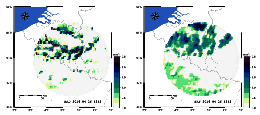
Comparison between radar and satellite (H03) data on April 26, 2016 (12:15 UTC).
Although cloud cover is quite common in Belgium during the winter months, making satellite snow detection a challenging undertaking, the prolonged anticyclonic conditions of February 2018 allowed good observations over cloud-free ground. Examples are shown in the following figures.
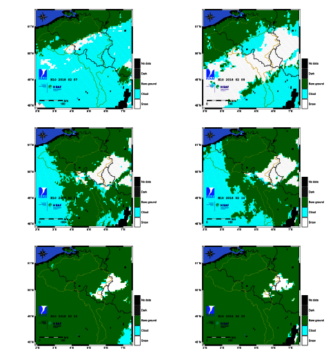
Images from snow product H10 for several days in February 2018, showing the evolution of snow cover in Belgium.
Execution
The H-SAF project started on 2005 and is still ongoing.
Currently it is in its Third Continuous Development and Operation Phase (CDOP-3) which started on March 2017 and will last until February 2022.
RMI participants:
- Emmanuel Roulin (scientific coordination and administration);
- Pierre Baguis (scientist).
Partner institutions:
- EUMETSAT
- Servizio Meteorologico Aeronautica Militare (IT)
- Protezione Civile Nazionale (IT)
- Zentralanstalt für Meteorologie und Geodynamik (AT)
- Finnish Meteorological Institute (FI)
- European Centre for Medium-Range Weather Forecasts
- Turkish State Meteorological Service (TR)
- Institute of Meteorology and Water Management (PL)
- Institute of Atmospheric Sciences and Climate (IT)
- TELESPAZIO (IT)
- Országos Meteorológiai Szolgálat (HU)
- Météo-France (FR)
- National Institute of Meteorology and Hydrology (BG)
- Royal Meteorological Institute of Belgium (BE)
- Slovenský hydrometeorologický ústav (SK)
- TuWien (AT)
- German Federal Institute of Hydrology (DE)
- Anadolu University (TR)
- Università di Ferrara (IT)
- Istanbul Technical University (TR)
- Middle East Technical University (TR)
- Ondokuz Mayis University (TR)
Funding source: EUMETSAT
List of abbreviations
EUMETSAT: European Organisation for the Exploitation of Meteorological Satellites
EUMETCast: EUMETSAT dissemination system based on multicast technology
MW: Microwave
IR: Infrared
VIS: Visible
GEO: Geosynchronous Equatorial Orbit
LEO: Low Earth Orbit
MetOp: Meteorological Operational Satellites
ASCAT: Advanced Scatterometer
NRT: Near Real Time
SEVIRI: Spinning Enhanced Visible and Infrared Imager
SCHEME: Scheldt-Meuse Hydrological Model
EnKF: Ensemble Kalman Filter
References
Baguis, P. and Roulin, E. Soil Moisture Data Assimilation in a Hydrological Model: A Case Study in Belgium Using Large-Scale Satellite Data. Remote Sens. 2017, 9(8), 820; doi:10.3390/rs9080820.
Puca, S., Porcu, F., Rinollo, A., Vulpiani, G., Baguis, P., Balabanova, S., Campione, E., Ertürk, A., Gabellani, S., Iwanski, R., Jurašek, M., Kaňák, J., Kerényi, J., Koshinchanov, G., Kozinarova, G., Krahe, P., Lapeta, B., Lábó, E., Milani, L., Okon, L'., Öztopal, A., Pagliara, P., Pignone, F., Rachimow, C., Rebora, N., Roulin, E., Sönmez, I., Toniazzo, A., Biron, D., Casella, D., Cattani, E., Dietrich, S., Di Paola, F., Laviola, S., Levizzani, V., Melfi, D., Mugnai, A., Panegrossi, G., Petracca, M., Sanò, P., Zauli, F., Rosci, P., De Leonibus, L., Agosta, E., and Gattari, F.. The validation service of the hydrological SAF geostationary and polar satellite precipitation products. Nat. Hazards Earth Syst. Sci., 2014, 14, 871-889.
Rinollo, A., G. Vulpiani, S. Puca, J. Kanák, E. Lábó, L. Okon, E. Roulin, P. Baguis, E. Cattani, S. Laviola, and V. Levizzani. Definition and impact of a quality index for radar-based reference measurements in the H-SAF precipitation product validation. Nat. Hazards Earth Syst. Sci., 2013, 13, 2695-270.
Van de Vyver, H., and E. Roulin. Scale recursive estimation for merging precipitation data from radar and microwave cross-track scanners. J. Geophys. Res., 2009, 114, D08104, doi: 10.1029/2008JD010709.
Van de Vyver, H., and E. Roulin. Belgian contribution to the validation of the precipitation products of the Hydrology-SAF: methodology developed and preliminary results. 2008 EUMETSAT Meteorological Satellite Conference, Darmstadt, Germany, 8 – 12 September 2008, 8 pp.