RMI contribution to EUMETSAT Land Surface Analysis - Satellite Application Facility (LSA SAF).

Context and objectives
In the water cycle, land evapotranspiration is the water vapour exchange from the surface to the atmosphere, through ground or water bodies evaporation and vegetation transpiration processes. In meteorology, climatology and water studies, its assessment is essential. Water managers of environmental sectors require evapotranspiration monitoring for an advised decision of water use. Estimation at large scale is still very difficult, but recent advances in remote sensing pave the way to a better monitoring at continental scale.
In the frame of EUMETSAT Satellite Application Facility on Land Surface Analysis (LSA SAF, lsa-saf.eumetsat.int), an almost unique service has been initiated: a near-real time operational evapotranspiration map production, freely accessible, covering Europe, Africa and South America at an unprecedented spatial resolution since end 2009, thanks to the imagery from the Meteosat satellites.
New products on latent and sensible heat fluxes were developed in a second step and also became available.
Methodology
Remote sensing is gaining more and more interest for the land surface modelling applications and the development of new methods aimed at evapotranspiration monitoring. In this context, RMI has developed a physical model of energy exchange between soil-biosphere and atmosphere driven by LSA SAF products based on MSG/SEVIRI derived data (Ghilain et al., 2011). Land evapotranspiration estimates are produced in near real time over Europe, Africa and South America at 3 to 5 km spatial resolution.
At surface level, the energy balance (Rn), computed from the different components of short- and long-wavelength radiation (SW and LW, respectively), is distributed in 3 different fluxes: soil heat flux (G), sensible heat flux (H) and latent heat flux (LE). The latter one is the flux of water vapour produced by both soil evaporation and canopy transpiration. LE is the energetic variable directly related to ET, which indicates the rate of water evaporating from the surface (soil + biosphere).
Validation performed against in-situ measurements demonstrate the good quality of LSA SAF ET. Nevertheless, some deficiencies have been noticed in semi-arid environments. From both user’s experience and own validation, we have worked towards improvements and adding more feature.
LSA SAF ET V2 relies on more satellite data and it delivers in addition the surface latent (LE) and sensible (H) heat fluxes. Improvements include the use of vegetation variables (LAI, FVC) from satellite.
The use of vegetation state variables derived from satellites presents the advantage that it allows the detection of short-term local fluctuations to inter-annual variability of the vegetation health and productivity. The leaf area index used in this context is produced daily by LSA SAF at a spatial resolution of a few kilometres in the SEVIRI projection. The results of the comparison between ground observations and a version using satellite derived vegetation state variables shows a clear improvement over semi-arid in Europe and Africa.
Current work (CDOP-4 phase, 2022-2027): adaptation of LSA SAF methodology for exploitation of Meteosat Third Generation (MTG) potential.
Results
The LSA SAF ET algorithm produces in near real time ET estimates at MSG SEVIRI spatial resolution each 30 minutes (‘MET’ product). Results are generated operationally since mid-2009 over four regions (Europe, North and South Africa and the Eastern part of South America) inside the MSG field of view. Since 2015, the 4 windows are merged in a single image of the MSG disk.
LSA SAF ET V2 is in operation since March 2019. It includes as new products the latent (LE) and sensible (H) heat fluxes.
LSA SAF ET and surface fluxes V3 should be released in 2023, along with a reprocessed dataset from 2004, corresponding to the start of MSG operations.
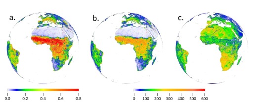
Figure. Example of a. instantaneous evapotranspiration (MET, mm/h), b. latent heat flux (LE, W/m2), c. sensible heat flux (H, W/m2), on 29th September 2016 at 12 TU.
MET is integrated over time to provide daily results (‘DMET’ product).
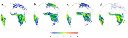
Figure. Daily evapotranspiration (DMET, mm/j). Examples for a. 15th March 2016, b. 15th June 2016, c. 15th September 2016, d. 15th December 2016.
- Data accessibility:
Registered users have free access to LSA SAF ET results over full disk through LSA SAF web site (see lsa-saf.eumetsat.int); near real time results are also accessible via EUMetCast); in case of problems/questions: please take contact with LSA SAF help desk or directly the RMI team;
Registered beta-users can access earlier results (new model versions) through LSA SAF ftp site.
- Expected interaction with users:
By giving us their feedback, users can contribute to improving the results.
Execution
Period: 1999 - present.
Current phase (CDOP-4): March 1, 2022 – February 28, 2027.
RMI participants: Alirio Arboleda, Miguel Barrios, Jan De Pue (scientists); Françoise Meulenberghs (scientific coordination and administration); Rafiq Hamdi (Steering Group member).
Partner Institutions: IPMA (PT), Meteo-France (FR), UV (ES), KIT (DE), IDL (PT), KCL (UK), VITO (BE), ARSO (SI), NIMH (BG).
Funding source: EUMETSAT, ESA/Belgian Science Policy (ESA/Contract Nr. 4000140626) and RMI.
References
- From RMI LSA SAF team:
Barrios, J.M.; Arboleda, A.; Dutra, E., Trigo, I, Gellens-Meulenberghs, F.: Evapotranspiration and Surface Energy Fluxes across Europe, Africa and Eastern South America throughout the operational life of the Meteosat Second Generation satellite. Submitted in 2023 to Geoscience Data Journal.
Ghilain, N., Arboleda, A. and Gellens-Meulenberghs F., 2011: Evapotranspiration modelling at large scale using near-real time MSG SEVIRI derived data. Hydrol. Earth Syst. Sci., doi:10.5194/hess-15-771-2011, 15, 771–786.
Ghilain, N., Arboleda, A., Barrios, J. M. and Gellens-Meulenberghs, F., 2018: LSA-SAF ET&SF – version 2: monitoring evapotranspiration & surface heat fluxes over entire continents at kilometer scale in near-real time thanks to satellite data. Abstract, EGU 2018, 8-13 April, Vienna, Austria.
Ghilain, N., Arboleda, A., Barrios, J. M., Gellens-Meulenberghs, F., 2020: Water interception by canopies for remote sensing based evapotranspiration models. International Journal of Remote Sensing, 14(8), 2934-2945, DOI: 10.1080/01431161.2019.1698072.
Ghilain, N., Arboleda, A., Batelaan, O., Ardö, J., Trigo, I., Barrios, J. M. and Gellens-Meulenberghs, F., 2019: A new retrieval algorithm for soil moisture index from thermal infrared sensor on-board geostationary satellites over Europe and Africa and its validation. Remote Sensing, 11(17), 1968; https://doi.org/10.3390/rs11171968.
Ghilain, N., Arboleda, A., Sepulcre-Cantò, G., Batelaan, O., Ardö, J. and Gellens-Meulenberghs, F., 2012: Improving evapotranspiration in land surface models by using biophysical variables derived from MSG/SEVIRI satellite. Hydrol. Earth Syst. Sci., doi:10.5194/hess-16-2567-2012, 15, 2567-2583.
Trigo, I., DaCamara, C., Viterbo, P., Roujean, J.-L., Olesen, F., Barroso., C., Camacho-de-Coca, F., Carrer, D., Freitas, S., García-Haro, J., Geiger, B., Gellens-Meulenberghs, F., Ghilain, N., Meliá, J., Pessanha, L., Siljamo N., Arboleda., A., 2011: The Satellite Application Facility on Land Surface Analysis. Int. J. Rem. Sens., 32(10), 2725–2744.
- From users (examples):
Hu, G., Jia, L., & Menenti, M. 2015: Comparison of MOD16 and LSA-SAF MSG evapotranspiration products over Europe for 2011, Remote Sens. Environ., 156, 510-526.
Petropoulos P., G., Ireland, G., Lamine, S., Griffiths, H., Ghilain, N., Anagnostopoulos, V., North, M., Srivastana, P., Georgopoulou, H. , 2016): Operational evapotranspiration estimates from SEVIRI in support of sustainable water management, International Journal of Applied Earth Observation and Geoinformation 49, 175-187.
Romaguera, M., Krol, M. S., Salama, M., Hoekstra, A. Y., & Su, Z., 2012: Determining irrigated areas and quantifying blue water use in Europe using remote sensing Meteosat Second Generation (MSG) products and Global Land Data Assimilation System (GLDAS) data, Photogrammetric Engineering & Remote Sensing, 78(8), 861-873.
Romaguera, M., Salama, M. S., Krol, M. S., Hoekstra, A. Y., & Su, Z., 2014: Towards the Improvement of Blue Water Evapotranspiration Estimates by Combining Remote Sensing and Model Simulation, Remote Sensing, 6(8), 7026-7049.
Sepulcre Canto, G., Vogt, J., Arboleda, A, Antofie, T., 2014: Assessment of the EUMETSAT LSA-SAF evapotranspiration product for drought monitoring in Europe, Int. J. Applied EO Geoinf, 30, 190-202.