You are here: Hydroland » Projects » Ended projects » HiWET
High-resolution modelling and monitoring of water and energy transfers in wetland ecosystems (HiWET).
Context and objectives
Freshwater wetlands are among the most diverse ecosystems in the world. The societal value of these ecosystems is enormous in virtue of the many ecosystem services they provide. Despite the protected status of many freshwater wetlands, many of these ecosystems are threatened by climatic anomalies and anthropogenic activities. Hence the importance of developing monitoring tools on crucial aspects of the health status of these ecosystems.
In this context, this project aims at evaluating evapotranspiration (ET) as a valuable parameter for monitoring the ability of wetlands to provide ecosystem services. The strategy in the HiWet project is the exploitation of the strengths of two major ET modelling paradigms: ET as an element of the hydrological balance and ET in the frame of energy fluxes between the Earth's surface and the atmosphere. The modelling strategy also considers the use of various models running at different spatial scales in wetland sites in Belgium, Luxembourg and Poland. Highly detailed information has been collected from dedicated airborne campaigns and intensive field surveys.
For further details see the HiWET web site (http://www.hydr.vub.ac.be/projecthiwet/).
Methodology
The combination of surface energy balance methods with hydrological models, a new ‘multi-scale hydrological water balance modelling (for wetlands) is developed that is innovative at two levels:
- Dynamic remote sensing data at different resolutions are used as new data sources to feed the hydrological models (in addition, or as replacement to the traditional 'old' static land/soil/topography maps and weather observations) whereby input and model uncertainties are considered and the obtained output uncertainties (evapotranspiration and flow) are minimised.
- A new paradigm for distributed river basin modelling is proposed on the basis of hydrological and energy balance modelling.
Results
RMI team contributes to HiWET doing research on moderate/high resolution modelling water and energy transfers in wetland.
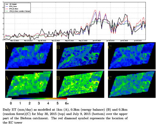
Estimates of daily ET have been derived at 1 km and 0.3 km spatial resolutions, i.e. over the grids of Proba-V 1 km and 0.3 km imagery. The ET estimates resulted from performing a pixel-based energy balance forced by satellite and meteorological data in addition to parameters related to the land cover classes. Furthermore, the 1 km estimates were statistically downscaled through Random Forest modelling. The seasonal patterns of vegetation were obtained from Proba-V observations and were key for achieving the target spatial resolutions. The study was performed in the upper basin of the Biebrza river, in Poland. The following Figure shows the modelled ET time series as contrasted with validation data obtained from an eddy covariance station as well as ET maps for two dates.
Execution
Period: 10/2014 – 12/ 2018.
RMI participants: Miguel Barrios (developer and scientist), Nicolas Ghilain and Françoise Meulenberghs (scientific coordination and administration).
Partner Institutions: VUB, UA, CRP-GL (LU), UNESCO-IHE, WULS (PL).
Funding source: Belspo Stereo3 program (contract SR/00/301) and RMI.
References
Barrios, J.M., Ghilain, N., Arboleda, A., and Gellens-Meulenberghs, F., 2017: Evaluating an energy balance setting and random forest-based downscaling for the estimation of daily ET at sub-kilometer spatial resolution. Proccedings of the 9th International Workshop on the Analysis of Multitemporal Remote Sensing Images (MultiTemp): DOI: 10.1109/Multi-Temp.2017.8035226.
Barrios, J. M., Ghilain, N., Arboleda, A., Sachs, T. and Gellens-Meulenberghs, F., 2018: Daily evapotranspiration at sub-kilometre spatial resolution by combining observations from geostationary and polar-orbit satellites. International Journal of Remote Sensing, DOI: 10.1080/01431161.2018.1504340.
Barrios, J. M., Ghilain, N., Arboleda, A. and Gellens-Meulenberghs, F., 2019: Daily evapotranspiration at sub-kilometre resolution through surface energy balance modelling and Random Forest-based downscaling. EGU2019, Vienna, 8-12th April 2019.
Ghilain, N., Arboleda, A., and Gellens-Meulenberghs, F., 2011: Evapotranspiration modeling at large scale using near-real time MSG SEVIRI derived data, Hydrol. Earth Syst. Sci., 15, 771-786.
Ghilain, N., Arboleda, A., and Gellens-Meulenberghs, F., 2012: Monitoring evapotranspiration at sub-kilometer scale: downscaling MSG/SEVIRI images using moderate resolution remote sensing derived data, proceedings of the EARSeL symposium, 9 pp.